Stage two was included as part of the main contract scope, which included the requirement for pre-lay engineering surveys to be carried out by the appointed contractor to confirm the findings from the initial surveys and develop the final cable route design.
Completion of Geophysical, Geotechnical and UXO Surveys for Subsea Site Characterisation
This is the 2nd edition of a blog series to outline how pre-construction works have progressed. For the 1st edition, see here.
The Hawar Island Submarine Cable project completed a significant milestone in early June, with the successful conclusion of the pre-cable lay marine surveys.
While installing power cables on land has many challenges, installing cables beneath the seabed in water depths of up 18 metres can present some significantly larger challenges, with greater risks and unknowns. ESB International utilised its experience from multiple submarine cable installation projects throughout Ireland and the Middle East to mitigate any potential project delivery risks and reduce any commercial risks that the client may be exposed to.
Mitigation of Project Risks
Reducing submarine cable project risks is done through detailed marine surveys, which develop a subsea site characterisation, giving a clearer view of ‘what lies beneath' the seabed. A sound understanding of the below seabed conditions allows effective planning to ensure the successful installation of the submarine cables.
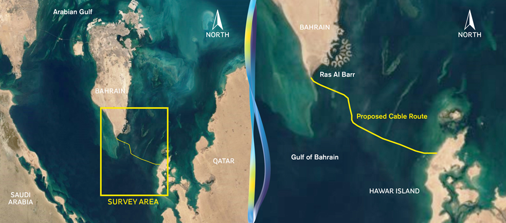
At two stages of this project, ESB International commissioned specific marine surveys for the three 66 kV, 3-core submarine power cable 25 kilometre circuits between the Bahrain mainland and Hawar Island. The first stage, the project feasibility phase stage, included the initial geophysical and geotechnical surveys to establish the optimum marine cable route and complete the Environmental Impact Assessment as per the Bahrain Supreme Council of the Environment requirements. The survey data has also assisted the tenderers in bidding for the project.
Due Diligence
Following technical evaluations conducted by ESB International, a Marine Survey company was contracted by the main contractor to undertake the pre-lay Marine Survey, which was divided into three main survey types; Geophysical, Geotechnical and UXO (Unexploded Ordinance) surveys, of each of the three submarine cable circuits (of approx. 25 kilometre route length) with a survey corridor width of 200 metres.
The key objective of the pre-lay marine survey was to confirm the information gathered in the initial geophysical and geotechnical surveys while gathering additional geophysical and geotechnical data. This provided the submarine cable installer with detailed data for the design and micro-routing of the subsea cable route.
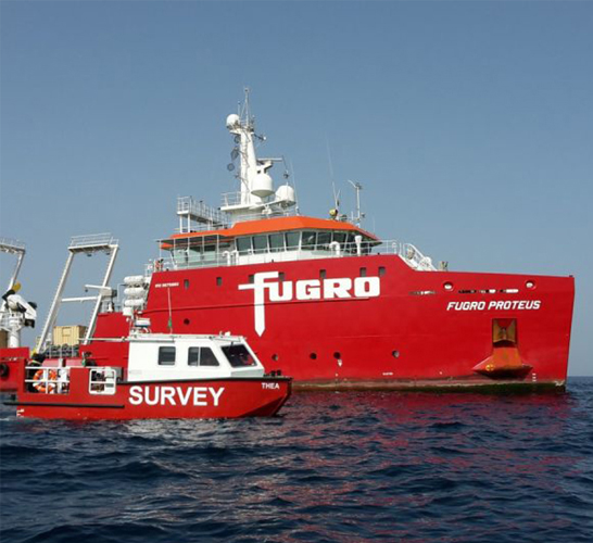
To accommodate the work, a survey mother ship with crew and surveyor accommodation accompanied by two survey boats sailed from their base in Abu Dhabi to the offshore site in Bahrain.
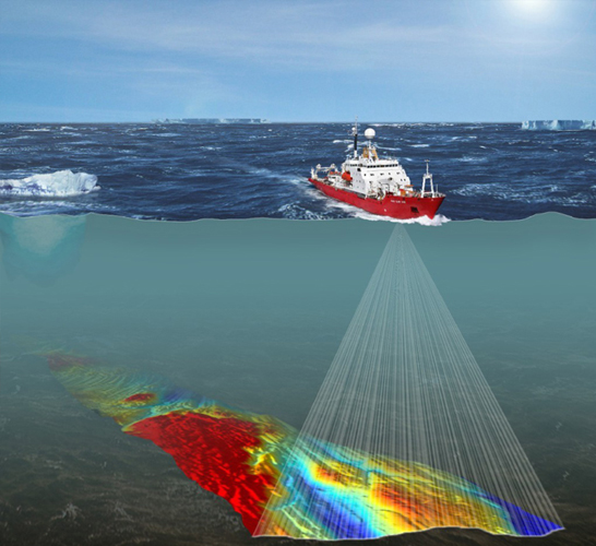
Geophysical Survey
The surveys were conducted between September 2020 and February 2021, using single beam (SBES) and multibeam echo sounders (MBES) with motion sensors, side-scan sonar (SSS), magnetometer (UXO), sub-bottom profiler (SBP) systems and transverse gradiometer in conjunction with Global Navigation Satellite System (GNSS).
Geotechnical Survey
The geotechnical survey consisted of vibrocoring samples along the length of the route. Vibrocoring surveys are a common method for obtaining core samples from the ocean floor, specifically from the sub-strata sediments, and would inform the type of cable installation method required. The process consists of a vibrating mechanism attached to a metal core which is then driven into the sediment using both vibration and the force of gravity. Positioning of the vibrocore equipment was assisted using the Global Navigation Satellite System (GNSS), and the survey work was completed between May and June of 2021.
Both the geophysical and geotechnical surveys involved collecting high resolution geophysical, benthic, and geotechnical data along the proposed cable route. Prominent seabed features detected within the proposed route corridor included seabed depressions, scarp and irregularities, pinnacles, boulders, seabed scars and ridges, sand ripples and pitting as well as dredging and the presence of rock outcrops. Of significance was the presence of isolated and closely spaced seabed depressions formed during military exercises in the area.
The data will be processed and analysed to characterise site conditions, including bathymetry, seafloor morphology, subsurface geology, environmental and biological sites, seafloor obstructions, soil conditions and archaeological resources. The submarine cable installer will then use this information to design and install the three 66 kV submarine cable circuits between Bahrain Mainland and Hawar Island.
UXO Survey
As initiated above, part of the proposed cable route was previously a military training zone, and as such, ESB International, with safety as our key priority, deemed it prudent to survey and check the entire cable route for any potential explosive remnants that may present a risk during cable installation and operation.
A UXO (Unexploded Ordinance) survey was required; this involves a specialised investigation of the seabed and its sub-surface using a magnetic scanning tool called a magnetometer. The magnetometer is towed behind the survey vessel and can operate from very shallow to deep-water conditions.
UXO surveys bring safety, budgetary and programme benefits to development projects such as these by enabling potentially dangerous objects to be avoided or removed and by mitigating or reducing delays during the cable installation phase. The survey identified several potential UXO ordinance (pUXO), and these will need further investigation and/or removal by a specialist Explosive Ordnance Disposal (EOD) Company.
The tendering process to appoint an EOD Specialist is currently underway, and it is planned to have UXO Identification and removal works in progress by Q4 2021.
Key Challenges
As the global impact of the Covid 19 pandemic changes day by day, ESB International continually puts health and safety first, prioritising safe working environments for our staff, contractors and our esteemed clients while focusing on continuing operations.
Despite the challenges imposed by the pandemic, the pre-lay survey was completed with zero cases of Covid 19. This was achieved in conjunction with the survey contractor, where ESB International developed a robust Pandemic Response Plan to ensure minimum disruption to ongoing works.
The plan strictly limited access to the survey vessels to allow the crew to remain in their own ‘bubble’ onboard; however, the introduction of Virtual Client Representative software meant that ESB International could monitor and manage the survey remotely. This included virtual file exchange, virtual meetings, virtual weather monitoring, a virtual witness of vessel position and live CCTV camera access.
Fishing is a significant economic activity and livelihood in Bahrain and is seen as an integral part of the kingdom’s history and heritage. Protecting these values where the cable route passes through popular fishing zones is important, and close liaison with the fishing community and the Bahrain Coast Guard were key to completing the survey. Information regarding the ongoing works was issued through Notices to Mariners, newspaper articles and social media campaigns, and this helped reduce the number of incidences where survey equipment could become entangled in fishing tackle and enabled survey works to be successfully completed with minimal delays.
I will provide further updates as the project progresses.